This tour has 8 nodes/spots in all. To view each of the spot, please hover the mouse over the thumbnails and click on it in the bottom middle of the tour window. If you wish to view this sopt on the tour map, click on the Map button on the left bottom corner.
Siddavatam Fort
People called “Siddhas” were living in this area. They used to live under trees called “vata” (Indian Banyan tree) which were plenty in this area at that time. Hence the name “Sidhas” + “Vata” = Sidhavata, or simply Sidhout. Sidhout lies in the banks of river Penna and surrounded by natural canyons.which are a rarely seen in the south india.
Siddavatam Fort, one of the architectural marvels of the fourteenth century situated in Cuddapah District, Andhra Pradesh. The indomitable fort rises amidst 30 acres of land on the banks of River Pennar at the foot of Lankamala Hills in the route of Cuddapah – Badvel via Bhakarapet, is a standing testimony to the architectural skills, military strategy and aesthetics of medieval India. You will have to reach Siddavatam village, also known as Sidhout, 25 kms from Cuddapah. Siddavatam Fort is located near Rajampet, about 20 kms away.
History
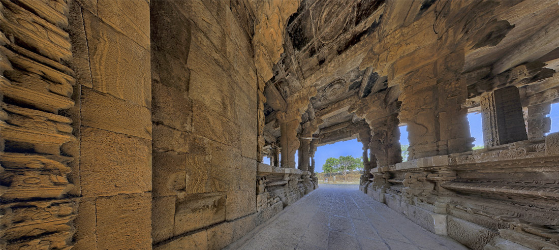
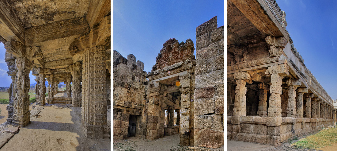
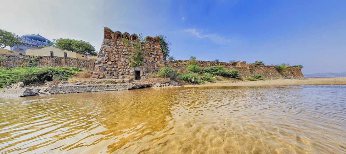
Sidhout Fort, constructed in 1303 AD, lies on the banks of the Pennar River. The fort extends over an area of 30 acres. Visitors can view gateways and decorated pillars at the two ends of the fort. Top of the fort has been adorned with carvings of Gajalakshmi. Moreover, the 17 square bastions which once used to protect the region are still visible in the fort.
The fort houses an ancillary passage which allows the visitors to gain access even after the closure of the main gates. It is considered as the gateway to Dakshina Kashi. The temples present inside its premise include the Ranganayaka Swamy Temple, Siddheswara Temple.
The fort here was much developed under the rule of king Varadha Raju, who is the son-in-law of Sri Krishna Deva Raya. This fort was just a mud fort at the time the area was ruled by “Matti Rajulu”. Later it came under the control of Varadha Raju.
Earlier it was a part of Udayagiri Kingdom. Matti Yellama Raju used to support the second Venkatapathi Rayalu in many wars. For this favour, Sidhout was given to Matti Yellama Raju as a gift along with some other places. Later Matti Anantha Raju remodelled the fort as Rock Fort.
Later Aurangajeb’s commander Mr Jumla II captured Sidhout. Later Aarkatu Nawabs occupied Sidhout. In 1714 Abdul Nabi Khan, who was ruling Kadapa conquered Sidhout. This place was also ruled by Mayana Nawabs for some period. Despite the fact that the Mayans hailed from Islam, they allowed the mantapams and the sculptures to remain intact. Later, during a war in 1779-80 when Hyder Ali of Mysore attacked the dynasty. Somehow, during this time, Sidavattam Fort was destroyed. Thus the historical fort passed into the hands of the Nizams of Tippu Sultan.
In 1800, Sidavattam Fort was taken over by the British East India Company. Cuddapah District was administered by the British from Siddavatam Fort from 1808-1812 as the district headquarters. Since it is on the bank of river Penna, every time the river floods, the place was used to get isolated. Hence the district headquarters were shifted to Cuddapah.after which the district administration shifted to the present town of Cuddapah (also spelt as Kadapa).
This popular fort was taken under control by Archaeology Department of India in 1956.
You can reach Siddavatam Fort is about 20 km away from Cuddapah on Cuddapah – Badvel route.
Where to stay
AP Tourism’s Haritha Resorts are about 20 kilometers towards Cuddapah and 19 Kilometers towards Ontimitta. Besides, there are many options found in Cuddapah suiting various budgets.
http://www.harithahotel.com/Ontimitta-Kadapa/
http://www.harithahotel.com/Kadapa-Haritha/